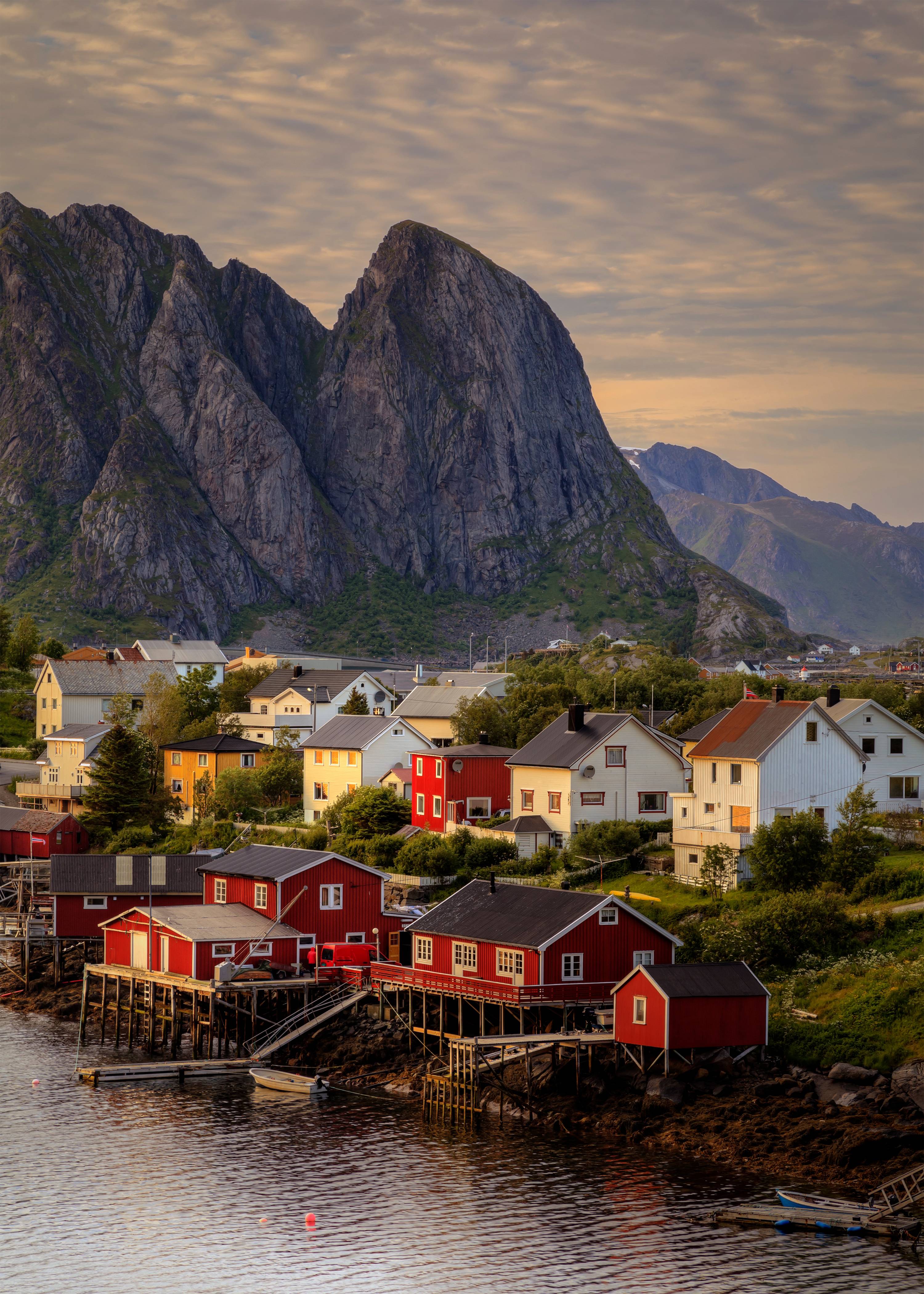
Lofoten has some of the most dramatic hiking in Europe — sharp granite peaks rising straight from the sea, beaches you reach only on foot, and 24-hour daylight in summer that lets you summit at midnight with nobody else around. This guide covers the best hikes we know, with the real numbers: elevation, time, difficulty, and the local tips that don't show up on AllTrails.
When to hike in Lofoten
Hiking season runs June through September. Snow clears on most peaks by late June. August is peak season — clearest trails, most stable weather, midnight sun still shining until late July. September adds autumn colour and the first aurora chances, but days get shorter fast.
Winter hiking (November–March) is a different discipline entirely. Crampons and ice axes are required for most summits. The snow transforms the routes and the views, but you need experience or a guide.
Season at a glance
Safety note: Reinebringen is the most frequent helicopter rescue spot in Lofoten. Never hike in trainers. Check varsom.no for avalanche risk in winter. Always tell someone your route and expected return.

1. Reinebringen
Moskenesøya, near Reine
The signature Lofoten summit. The Sherpa-built stone staircase climbs steeply from the E10 near Reine, and from the top you get the classic view over Reine harbour, Sakrisøy, and Hamnøy — the image that appears on every Lofoten postcard. The physical effort is high despite the moderate classification because the staircase is relentlessly steep.
The trailhead is at the old road bypass near the Ramsvik Tunnel on the E10. Parking is extremely limited — arrive before 9am in July or hike at 11pm under the midnight sun when nobody else is there.

2. Ryten & Kvalvika Beach
Moskenesøya, Fredvang area
Two hikes in one. The trail from Fredvang splits — go left to Kvalvika Beach (a hidden cove you can only reach on foot), or continue up to the Ryten summit for an aerial view straight down onto the turquoise water. Most hikers do both. The Ryten ridge viewpoint looking down over Kvalvika is one of the most photographed spots in all of Northern Norway.
The trailhead is at Innersand, a short drive from the Fredvang bridges. The path is well-marked but gets muddy after rain, especially in the bog sections before the beach.

3. Hermannsdalstinden
Moskenesøya, above Sørvågen
The highest peak in the Lofoten Wall and the most serious day hike on the islands. At 1,029 metres it's the only peak that cracks 1,000m in the main Lofoten chain. The route from Sørvågen climbs through steep terrain with exposed sections near the top that require scrambling on rock. In good conditions the 360° panorama from the summit — fjords, open ocean, the entire archipelago below you — is one of the great views in Norway.

4. Munken
Moskenesøya, above Sørvågen
Often combined with or compared to Hermannsdalstinden, Munken is a demanding ridge hike that rewards with dramatic fjord views and a real sense of alpine exposure. The approach from the Sørvågen side climbs through increasingly steep terrain, and the final ridge has sections where you're walking along a narrow spine with drops on both sides.

5. Bunes Beach
Moskenesøya, via ferry from Reine
A wild beach accessible only by ferry + hiking trail, with towering cliffs on three sides and the open Atlantic on the fourth. Take the ferry from Reine to Vindstad, then hike over a low ridge to reach the beach. The walk itself is straightforward — the magic is the destination. White sand, dramatic walls of rock, almost no one there outside peak July weekends.
For a longer day, continue past Bunes Beach up to the Helvetestinden viewpoint for an aerial perspective straight down to the beach and out to the ocean.

6. Offersøykammen
Vestvågøya, near Leknes
A short, rewarding hike that most tourists miss because it's overshadowed by Reinebringen. The view from the top is arguably just as good — a panorama over the bridges connecting the islands, turquoise water, and the full spread of the Lofoten Wall. It's quieter, easier to park, and you can be up and down before lunch.

7. Festvågtinden
Austvågøya, above Henningsvær
The classic viewpoint hike above Henningsvær — Lofoten's "Venice of the North." From the summit you look straight down onto the fishing village spread across its tiny islands, the football pitch on the edge of the sea, and the bridges connecting it all. The trail is steep but short, making it perfect for an afternoon hike after exploring Henningsvær's galleries and cafes.

8. Mannen
Vestvågøya, above Haukland Beach
A family-friendly hike with an outsized reward. The trail climbs gently above Haukland Beach — one of Lofoten's most beautiful white-sand beaches — to a viewpoint where you can see both Haukland and Uttakleiv beaches from above. On a clear day, the water is Caribbean-turquoise (at 6°C, admittedly).

9. Tjeldbergtinden
Austvågøya, near Svolvær
The best short hike near Svolvær — perfect for your arrival day or when you want a quick summit without driving far. The trail starts right from town and climbs to a viewpoint over the Svolvær harbour, the surrounding peaks, and the Vestfjorden. Straightforward path, well-marked, no scrambling.

10. Matmora
Austvågøya, above Austnesfjorden
A gentle ridge walk that gives you big-mountain feelings without big-mountain difficulty. The trail follows a long, grassy ridge above Austnesfjorden with views that unfold gradually — first the fjord, then the surrounding peaks, then (if you keep going to the summit) a full panorama that rivals anything in Lofoten. The grade is mellow compared to the elevation gain because the ridge is long and gradual.
Quick comparison
| Hike | Difficulty | Elevation | Time | Best for |
|---|---|---|---|---|
| Reinebringen | Moderate | 448m | 1.5–2h up | The iconic view |
| Ryten & Kvalvika | Moderate | 543m | 3–5h round | Beach + summit combo |
| Hermannsdalstinden | Hard | 1,029m | 7–9h round | Serious mountaineers |
| Munken | Hard | 798m | 6–8h round | Ridge walking |
| Bunes Beach | Easy | ~150m | 1.5–2h one way | Wild beach adventure |
| Offersøykammen | Easy | 436m | 1.5–2.5h round | Quiet alternative to Reinebringen |
| Festvågtinden | Moderate | 541m | 2–3h round | Views over Henningsvær |
| Mannen | Easy | ~400m | 1.5–2.5h round | Families, beach combo |
| Tjeldbergtinden | Easy | 366m | 2–3h round | Arrival day, near Svolvær |
| Matmora | Easy–Mod | 788m | 2.5–4h round | Ridge walk, locals' favourite |
What to pack
Lofoten weather changes fast. Even in July, rain can arrive in minutes and temperatures drop sharply at altitude.
- Hiking boots with ankle support — not trainers, not trail runners. The Sherpa stairs on Reinebringen are slippery when wet.
- Waterproof jacket — this is non-negotiable. Rain arrives suddenly even on clear mornings.
- Layers — summit temperatures can be 10–15°C colder than sea level.
- Sunscreen and sunglasses — midnight sun means UV exposure at all hours.
- Blackout eye mask — for sleeping. The sun doesn't set May 25 – July 17.
- Water and snacks — no facilities on any of these trails.
- Offline maps — phone signal drops in valleys and tunnels.
Getting around Lofoten
You need a car. The trailheads are spread across 170km of the E10 road. Bus service (Route 300) exists but runs only 2–4 times daily and won't get you to early-morning trailheads.
Rent a car in Svolvær or at Leknes airport. Roads are narrow with single-lane bridges. Sheep wander onto the road. Speed cameras are active. Download offline maps before you leave — mobile signal drops in tunnels.
Parking warning: Trailhead parking is extremely limited in July, especially at Reinebringen and Ryten. Arrive before 9am or hike in the evening under the midnight sun. Never park on grass or soil — it's illegal in Norway.
Ready to plan your hiking trip?
TripTide builds day-by-day Lofoten itineraries with real operators, seasonal tips, and estimated costs — in minutes.
Plan a Lofoten hiking tripLast updated April 2026. Trail data sourced from local operators, Lofoten Mountain Guides, and verified field research. Conditions change — always check varsom.no and yr.no before heading out.